


Hurricanes Resources for Gulf Communities
Use the links below to find everything from National Hurricane Center forecasts, to current models and even the GCOOS autonomous vehicle dashboard, which tracks gliders and other vehicles in the Gulf as they gather data used in hurricane predictions. Each season, two main forecasts predict the upcoming June-November hurricane season in the Mid-Atlantic/Gulf region.
Hurricane Prediction Resources
National Hurricane Center

National Weather Service

NOAA Storm Prediction Center

Colorado State University Tropical Cyclone Research and Forecasting

The Eyewall

National Weather Service — Hurricane Planning Tips

GCOOS Hurricane Data Resources
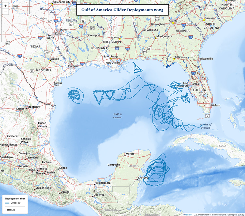
GCOOS Glider Dashboard

Hurricane modelers and forecasters rely on ocean temperature and other data from autonomous vehicles to help predict storm development, intensity and even movements. GCOOS developed a tool nicknamed GANDALF — the Gulf of America AUV Network, Data Archive and Layer Fusing — to track these vehicles, help pilots plot their courses and visualize data they gather.
In 2025, GCOOS released GANDALF 2.0, which offers significant improvements in rapid layer loading, new legends and three-day hind-, now- and forecast animations on the model outputs. We’ve also added the NOAA Electronic Navigational Charts (ENC) General Charts as a new tile layer that is much more performant and contains far more detail. GANDALF also now offers water temperature and salinity anomaly comparisons that are run automatically and updated in near real-time.
GCOOS Model Handler

In 2025, GCOOS released version 2.0 of its Regional Model Handler/Viewer (ReMHV). The ReMHV is an online platform that allows users to visualize and analyze various oceanographic and meteorological model outputs for the Gulf and integrates real-time observations with simulated data (like currents, temperature, wind) in a map-based interface.
BSEE/NTL Data Repository & Registry

Since 2021, GCOOS has been hosting the Bureau of Safety and Environmental Enforcement (BSEE) Notice to Lessees and Operators (NTL) data. This portal provides offshore operators, researchers and managers with access to crucial oceanographic/metocean (meteorological and oceanographic) data required by BSEE regulations, and transforms it into an actionable resource for both industry compliance and broader environmental stewardship and safety.
High Frequency Radar Data Portal

High frequency radar (HFR) measures the speed and direction of ocean surface currents in near-real time. The information is crucial for conducting search and rescue operations, tracking contaminant spills and providing vital information for ship navigation safety, where immediate information about ocean height is necessary to move large vessels in and out of ports and channels.


Making hurricane predictions is all about having data — and being able to access accurate information quickly and easily. For the third year in a […]


