


Each year, underwater glider pilots in the Gulf of Mexico work together to deploy gliders to gather information needed to inform meteorological models and storm predictions. Operators are focused on collecting in-situ data within ocean features ahead of storms so that information can be assimilated into National Weather Service models. Of particular importance is gathering temperature and salinity data.
Gliders can also provide key information about the movements of the Loop Current (LC), which is getting a lot of attention right now because conditions this year seem similar to 2005, when Hurricane Katrina devastated Louisiana.
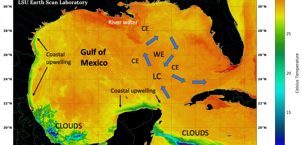
GCOOS Board Member Dr. Nan Walker, Director of the Earth Scan Laboratory at Louisiana State University, says that although the LC is not the warmest water in the Gulf, it is the largest source of heat and can intensify tropical storm systems that track over it, as its warm water extends more than 300 feet deep (provided that atmospheric conditions are also conducive).
- Learn more about the LC’s current location based on satellite imagery here.
- Walker recently talked with WWNO New Orleans Public Radio about the LC and the role it plays in hurricane intensity. Read the story.
GCOOS Board Member Dr. Nick Shay, from the University of Miami’s Rosenstiel School of Marine and Atmospheric Science, has also been discussing the LC and was featured in the Houston Chronicle and The Conversation.
Says Shay: “I have been monitoring ocean heat content for more than 30 years as a marine scientist. The conditions I see in the Gulf in May 2022 are cause for concern. The National Oceanic and Atmospheric Administration is forecasting an above-average Atlantic hurricane season, with 14-21 named storms, six to 10 of them hurricanes. The Loop Current has the potential to supercharge some of those storms.”
A paper published in the peer review magazine Oceanography shows that gliders and other robotic ocean observing platforms can improve intensity forecasts for hurricanes and tropical storms and should be supported as a crucial component of the ocean infrastructure designed to protect the lives of coastal residents and mitigate the economic impact from storms.
In the paper, “Uncrewed Ocean Gliders and Saildrones Support Hurricane Forecasting and Research,” authors from more than a dozen governmental, nongovernmental and academic institutions involved in deploying these platforms during the 2021 hurricane season, including GCOOS, detailed how gliders improved intensity forecasting and further, how adding Saildrones operating in close proximity improved intensity forecasting even more.
- Read more
- Read the full paper
- Watch a story on AccuWeather
- Keep up with the latest hurricane news on the GCOOS data portal


