


GCOOS and its partners are launching and tracking autonomous vehicles in the Gulf, Atlantic and Caribbean — including in the potential path of Tropical Storm Idalia
In the U.S., hurricanes have caused more than $1 trillion in losses since 1980 — 2022’s Hurricane Ian caused more than $112 billion in damages alone. While the landfall forecasts that drive evacuation orders and guide coastal preparations ahead of storms have been steadily improving, storm strength forecasting has lagged.
To help bridge the data gap and improve forecasts, this month, the Gulf of Mexico Coastal Ocean Observing System (GCOOS) and its key scientific and data-gathering partners are launching autonomous vehicles in the Gulf, Caribbean and Atlantic waters. These uncrewed systems, which can operate even during dangerous conditions, gather and transmit critical ocean temperature data in near-real-time that can be used immediately by hurricane modelers to help predict how and where storms will develop and how intense they could become. These factors are critically important for protecting lives in the face of destructive hurricane-force winds and storm surge.
The intensity of hurricanes is influenced by many factors — atmospheric circulation, internal storm dynamics, air-sea interactions, boundary currents — but ocean heat content is perhaps the most critical factor driving storm intensification.
“Much of the focus of our missions during hurricane season is on gathering ocean temperature data in the upper water column to depths of up to 200 meters (656 feet) in the Gulf, because that is one of the main driving factors for storm intensification,” says GCOOS Oceanographer Dr. Uchenna Chizaram Nwankwo, who helps to coordinate underwater glider missions and seasonal planning in the Gulf. “We also track the Loop Current (LC) and the eddies that break off from it because they transport warmer water that fuels hurricanes, too.”
With record highs being recorded in oceans around the world, temperatures in the Gulf of Mexico and Atlantic topping the 90-degree mark, and the National Oceanic and Atmospheric Administration (NOAA) upgrading its 2023 hurricane season outlook to “above normal,” information on ocean temperatures is more important than ever, said GCOOS Executive Director Dr. Jorge Brenner.
“NASA just recorded the hottest July on record, and with the changing climate, hurricanes are only expected to increase in number and intensity,” Brenner said. “Using uncrewed systems like Slocum gliders, Seagliders and Saildrones helps us bridge key data gaps. GCOOS is also able to serve the data to forecasters at agencies like the National Weather Service almost as soon as they come in — it’s getting the data in near-real time that will help us truly make a difference in forecasting storm intensification.”
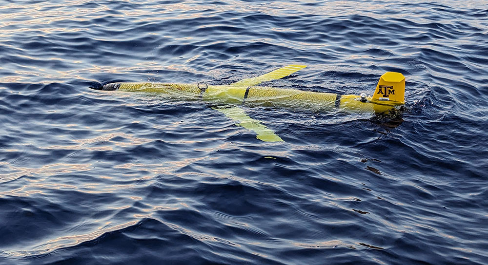
Right now, GCOOS is tracking and sharing data from 23 Slocum gliders, Seagliders and Saildrones patrolling the Caribbean, Gulf of Mexico and the Southeast Atlantic. Slocum and Seagliders are underwater robots that collect ocean data in remote locations and at depth and can be programmed and piloted remotely to conduct specific missions. They communicate with satellites, allowing them to transmit ocean data to modelers and forecasters in real time or near-real time. Saildrones are wind and solar-powered vehicles that travel along the ocean’s surface as they gather data and transmit the information via satellite.
The vehicles are piloted by numerous organizations and agencies, including GCOOS/Texas A&M University’s Geochemical and Environmental Research Group (TAMU-GERG), NOAA, the Skidaway Institute of Oceanography, the University of Southern Mississippi (USM) and the University of South Florida (USF). The vehicles being tracked also include gliders on loan from the U.S. Navy that are provided to GCOOS each year to enhance storm intensification research.
Currently, USF is operating a Slocum glider and NOAA is operating a Saildrone in the potential path of Tropical Storm Idalia. Another USF glider, on a mission focused on harmful algal blooms, is also off Florida’s west coast and providing data that can be used in storm tracking and intensity forecasting.

- The missions of uncrewed systems are tracked on GCOOS’s piloting dashboard known as GANDALF.
Created by GCOOS Product Developer Robert Currier, GANDALF provides real-time vehicle positioning information via a maps-based interface with a dashboard display, plots of flight and science sensors such as temperature and salinity, Google Earth KMZ file generation and access to processed data files. GANDALF is equipped with numerous layers that can be individually displayed on the base map and each layer’s transparency can be individually adjusted allowing for multiple layer overlays.
This free and powerful visualization tool helps operators plan missions and pilot their vehicles and quickly and easily see the water column data each vehicle is collecting. The interface also allows modelers to easily ingest the data being gathered in near-real time to improve their models.
“For the last several years, researchers from multiple organizations have been working together to plan hurricane season missions to ensure we’re gathering data from key locations in the Gulf and Caribbean,” Brenner said. “Working together helps us all to maximize the information we’re gaining while at the same time we’re reducing costs and redundancy. It truly takes a team effort.”
For more information on how uncrewed systems are being used in hurricane forecasting:
- Read “Revolutionizing Hurricane Forecasting”
- Read the scientific paper: Miles, T.N., D. Zhang, G.R. Foltz, J. Zhang, C. Meinig, F. Bringas, J. Triñanes, M. Le Hénaff, M.F. Aristizabal Vargas, S. Coakley, C.R. Edwards, D. Gong, R.E. Todd, M.J. Oliver, W.D. Wilson, K. Whilden, B. Kirkpatrick, P. Chardon-Maldonado, J.M. Morell, D. Hernandez, G. Kuska, C.D. Stienbarger, K. Bailey, C. Zhang, S.M. Glenn, and G.J. Goni. 2021. Uncrewed ocean gliders and Saildrones support hurricane forecasting and research. Pp. 78–81 in Frontiers in Ocean Observing: Documenting Ecosystems, Understanding Environmental Changes, Forecasting Hazards. E.S. Kappel, S.K. Juniper, S. Seeyave, E. Smith, and M. Visbeck, eds, A Supplement to Oceanography 34(4).


