

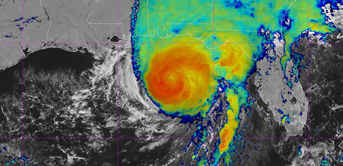
As Hurricane Isaias moves toward landfall along the northern Gulf Coast, the Gulf of America Coastal Ocean Observing System (GCOOS) is tracking data from monitoring stations and autonomous vehicles in real-time and near-real time that are helping to improve forecasting ahead of the storm.
Uncrewed systems, high-frequency radar, buoys, webcams and other platforms that operate even during dangerous conditions, are gathering and transmitting critical ocean temperature data in near-real-time that is used immediately by hurricane modelers to help predict how and where storms move and how intense they could become. Buoys and radar are also tracking wave heights — important information to track coastal flooding. These factors are critically important for protecting lives in the face of destructive hurricane-force winds and storm surge.
GCOOS’s mission is to provide timely, reliable and accurate information on the open ocean and coastal ocean waters of the Gulf to ensure a healthy, clean, productive ocean and resilient coastal zone. It works with governmental and nongovernmental organizations, universities, research laboratories and emergency managers throughout the Gulf of America to collect and share data.
“Within the last two years, GCOOS has worked with our partners in Texas, Louisiana, Mississippi, Alabama and Florida to increase instrumentation in the northern Gulf,” said GCOOS Executive Director Dr. Jorge Brenner. “These data are now streaming online for forecasters, emergency management professionals and the public to use to help determine ocean conditions and track storms. Now, with Hurricane Isaias bearing down on the northern Gulf these tools are more important than ever.”
Landfall for the category three storm is predicted to take place late today or early Saturday with storm surge of six to nine feet at the Florida/Alabama border. GCOOS has a webpage dedicated to hurricane-related resources (https://gcoos.org/hurricane-resources/) and also hosts a variety of ocean observing assets near or in the storm’s track that forecasters and modelers are watching closely, including:
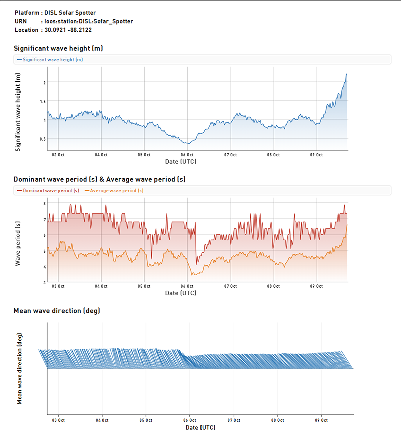
Experts predict that a small spotter buoy operated by GCOOS partner Dauphin Island Sea Lab in Alabama is in the direct pathway of the storm. In addition to collecting data used in real-time during storm tracking, forecasters and modelers use data like these for post-storm analyses that help to improve future forecasts.
Autonomous Vehicles
- Two Oshen C-Star autonomous surface vehicles (ASV) operated by NOAA’s Atlantic Oceanographic and Meteorological Laboratory (AOML). These 4-foot-long vehicles are wind-propelled with solar-powered sensors, and transmit real-time data on wind speed and direction, sea surface temperature, air temperature, air pressure and relative humidity via satellite for forecasters and scientists. C-Stars are also equipped with electric motor thrusters to improve positioning to intercept a hurricane or when winds are weak.
- Two Saildrones operated by NOAA. These wind and solar-powered uncrewed surface vehicles (USV) are gathering data on wind speed and direction, gusts, air temperatures, significant wave heights and barometric pressure.
- A Seaglider operated by the University of Southern Mississippi. This autonomous underwater vehicle (AUV) is gathering data on water temperatures at depth and salinity. Users can also compare the actual data the Seaglider is collecting to the conditions predicted by key oceanic/weather models.
View the data from these assets at GCOOS’s Piloting Decision Support Tool: https://gandalf.gcoos.org
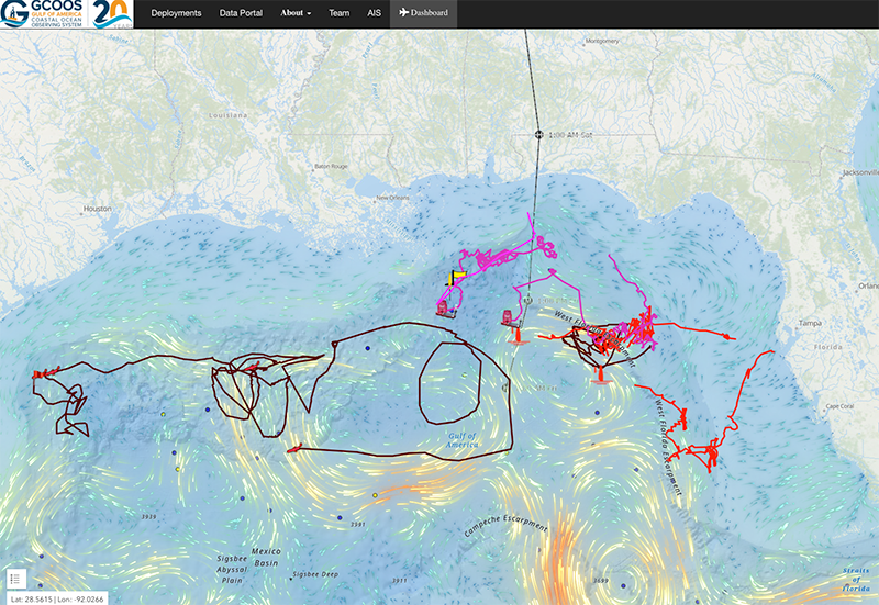
GCOOS created a dashboard that allows the pilots of uncrewed vessels to track their vehicles and automatically plot the incoming data. The lines on the map show the paths of the vehicles that GCOOS is currently hosting, including two C-Stars, two Saildrones and a Seaglider, that are in or near the projected path of Hurricane Isaias. See the data online at https://gandalf.gcoos.org
Buoys
Sofar Spotter buoys off Alabama and Pensacola coasts operated by the Dauphin Island Sea Lab (DISL). These small buoys were installed at the request of the National Weather Service to help track rip currents but the information these buoys gather data on waves, weather, and sea surface temperature. The Alabama buoy is moored about 10 miles from shore and the Pensacola buoy is moored about two miles from shore. These buoys are part of the DISL-operated Alabama’s Real-Time Coastal Observing System (ARCOS), a collection of weather stations gathering data in and around Mobile Bay.
View the data from these assets and other moorings at https://data.gcoos.org
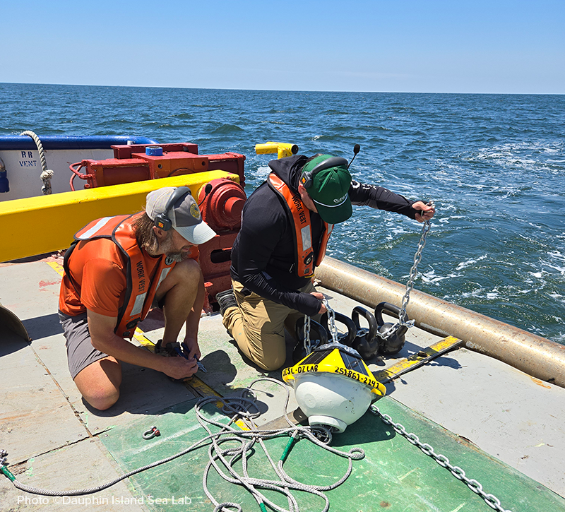
DISL installed a Sofar Spotter buoy in 2025 off the Alabama coast. That buoy is now in the path of Hurricane Isaias.
High-Frequency Radar (HFR)
GCOOS sposonrs HFR data from Singing River, Gulfport Harbor Pier and Pass Christian Yacht Club in Mississippi and Henderson Beach State Park in Florida operated by the University of Southern Mississippi. HFR measures the speed and direction of ocean surface currents in near-real time — providing accurate and timely information as quickly as possible to people who depend on the data. HFR data is particularly important for U.S. Coast Guard search-and-rescue operations, emergency response to oil, gas and other hazardous chemical spills and for the National Weather Service’s marine forecasts.
View the data from these assets at https://data.gcoos.org/hfradar/
Web Cameras
GCOOS also operates four web cams put in place as part of the national Webcam Coastal Observation System (WebCOOS). The cameras are both east and west of the landing path an hosted by the Tidewater Beach Resort at Panama City Beach, Florida, and Phoenix Gulf Towers in Gulf Shores, Alabama.
View the live feeds from these assets at https://webcoos.org
Looking for wave heights in specific areas? These six stations are in the path of Hurricane Isaias. To view the data, click the link then choose “Plot Data” to view wave data transmitted to GCOOS.
- WAVCIS Spotter Buoy, Station CSI07 https://data.gcoos.org/station_details.php?station=CSI07
- Scripps CDIP 256 Station https://data.gcoos.org/station_details.php?station=42084
- Scripps CDIP 279 Station https://data.gcoos.org/station_details.php?station=42354
- Mississippi State University Spotter Buoy SPOT 33441C https://data.gcoos.org/station_details.php?station=SPOT_33441C
- Mississippi State University Spotter Buoy SPOT 33439C https://data.gcoos.org/station_details.php?station=SPOT_33439C
- Dauphin Island Sea Laboratory’s Spotter Buoy https://data.gcoos.org/station_details.php?station=Sofar Spotter
These stations are providing data from the storm’s west side:
- Scripps CDIP 144 https://data.gcoos.org/station_details.php?station=42099
- COMPS SUBGEO2 https://data.gcoos.org/station_details.php?station=SUBGEO2
- COMPS SUBGEO21 https://data.gcoos.org/station_details.php?station=SUBGEO1
- Scripps CDI 214 https://data.gcoos.org/station_details.php?station=42098
- Scripps CDIP 244 https://data.gcoos.org/station_details.php?station=42095
These stations are providing data from the storm’s east side:
- UTMSI Spotter SPOT_33114C – Buoy 1415.02 – Environmental List (40 m) https://data.gcoos.org/station_details.php?station=SPOT_33114C
- UTMSI Spotter SPOT_33266C – Buoy 1415 – Environmental List (12 m) https://data.gcoos.org/station_details.php?station=SPOT_33266C
- UTMSI Spotter SPOT_33553C – Buoy 1415.01 – Hydro List (12m) https://data.gcoos.org/station_details.php?station=SPOT_33553C