


The University of South Florida and Florida’s Fish and Wildlife Conservation Commission’s Fish and Wildlife Research Institute are using data from underwater gliders to study how red tide blooms are initiated offshore, transported to coastal waters and eventually end.
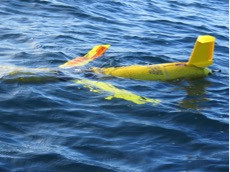
An autonomous underwater glider nicknamed Stella recently collected water data off the coast of Palm Harbor. Data collected by Stella will be incorporated in model simulations to shed light on how Florida red tide blooms are initiated offshore, transported to coastal waters, and eventually terminated. The glider mission was a joint effort between the University of South Florida College of Marine Science (USF CMS) and the Fish and Wildlife Conservation Commission- Florida Fish and Wildlife Research Institute (FWC-FWRI).
Red tide bloom developments vary seasonally and inter-annually. The recent Stella mission is particularly timely because it occurred during the spring transition — when ocean surface temperatures shift from fall/winter cooling to spring/summer warming. Dr. Bob Weisberg, USF oceanographer, notes that understanding the development of seasonal coastal upwelling — a condition when near-surface water moves away from the coast and is replaced by deeper water moving toward the coast-is important because it is possible to change the nutrient state of the entire West Florida Shelf. Dr. Weisberg and other researchers are interested in learning if this change in nutrients is conducive to the formation of a major red tide bloom.
Project partner Dr. Kate Hubbard, lead for FWC-FWRI’s Harmful Algal Bloom Monitoring and Research Program, is partnering with USF, Mote Marine Laboratory, GCOOS and SECOORA to search for cues that a red tide bloom might be forming or ending, predict when and where nearshore impacts might occur, and better understand why bloom severity varies geographically and over time.
Anyone can access glider data for free on GANDALF — the Gulf AUV Network and Data Archiving Long-term Storage Facility, which was developed by GCOOS. While a glider is in-water, GANDALF provides real-time glider positioning information via a map-based interface with a dashboard display, plots of science sensors, Google Earth KMZ file generation, and access to processed data files. Once the glider is retrieved, post-processing of mission data is provided.
“This glider operation is a true testament of a research institute and state agency collaborating in collecting in-situ data necessary to understand the dynamics causing and maintaining harmful algae blooms,” said Bill Lingsch, U.S. Underwater Glider User Group Coordinator. “This leads to forecasts and applications to raise public awareness to mitigate health impacts and also to prepare communities for the potential biological impacts. ”


