Featured News

The Underwater Glider that Could — and Did

By:
Posted: February 18, 2022
Category: Featured News

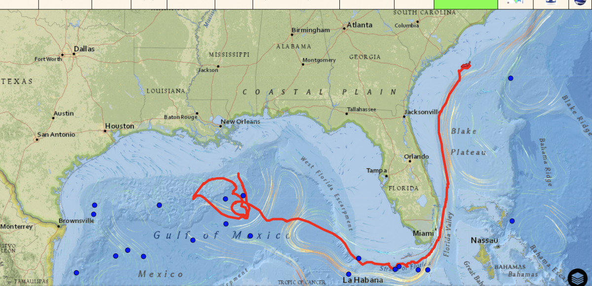
When the Slocum glider known as NG645 was deployed about 80 miles south of New Orleans on Oct. 10, 2021, it became one of the most closely watched ocean-observing instruments in the Gulf of Mexico.

That’s because it was a small robot with a big mission: Investigate features of the Loop Current and Loop Current Eddies in the Gulf as part of the Hurricane Glider Project, then travel south into the Gulf Stream, go around the tip of Florida, through the Florida Straits and north to South Carolina — a trip of some 2,387 miles (3,842 km). The trip was a test to see whether the glider could navigate around Florida and up the East Coast successfully while gaining information about multiple marine systems — all during a single mission. And it would have to do so using minimal battery power and only buoyancy — no propeller or motor — to travel.

The glider NG645 sets off on its mission after being deployed about 80 miles south of New Orleans. Photo by Bill Lingsch.

For the glider, the mission was fraught. Along this never-before-undertaken journey, it would have to contend with very strong currents, busy shipping channels, the possibility of tropical storms or hurricanes and even navigating through the U.S. EEZ (exclusive economic zone) without wandering into non-U.S. waters.

NG645 had a big cheering section and navigation team closely monitoring the mission, including members from:

  • The Naval Oceanographic Office (NAVOCEANO)
  • The U.S. Integrated Ocean Observing System (U.S. IOOS)
  • The Gulf of Mexico Coastal Ocean Observing System (GCOOS)
  • The Southeast Coastal Ocean Observing Regional Association (SECOORA)
  • The Underwater Glider User Group (UG2), a community organization of glider operators
  • The Geochemical & Environmental Research Group (GERG) at Texas A&M University (TAMU)
  • Skidaway Institute of Oceanography at the University of Georgia (SkIO/UGA)
  • University of Southern Mississippi (USM)
  • NOAA’s Atlantic Oceanographic and Meteorological Laboratory (AOML)
  • Woods Hole Oceanographic Institute (WHOI)

NAVOCEANO owns the glider and loaned it to the IOOS Glider Program as part of a Hurricane Glider Project to improve Atlantic hurricane intensity forecasts. The collaboration between Naval Research Labs-Stennis (NRL-Stennis) and IOOS also supports additional research on underwater features in the Gulf. NAVOCEANO monitored the glider with input from the IOOS Regional Associations GCOOS and SECOORA, along with AOML and WHOI, who helped design and direct its path.

“There were so many firsts during this mission,” said Dr. Kerri Whilden, GCOOS Oceanographer and Assistant Research Scientist at TAMU, who led the collaboration in the Gulf before handing it off to Dr. Catherine Edwards, Associate Professor at SkIO/UGA, as it rounded Key West and navigated up the East Coast. “It would be the first time we started piloting a glider in the Gulf and then sent it through the Gulf Stream around the tip of Florida, then on to South Carolina. It involved coordinating a lot of different organizations to deploy the glider, to pilot it and then to retrieve it at the end of its mission. It was a big team collaboration for sure.”

Slocum gliders, also known as autonomous underwater vehicles (AUVs), are torpedo-shaped underwater robots about 6 feet long and 8 inches in diameter that carry instrument packages that gather data on water temperature, salinity, dissolved oxygen and other ocean parameters, depending on ocean-observation needs. The gliders use buoyancy to move throughout the water column in a vertical yo-yo pattern, taking in water to move down through the water column and expelling water to return to the surface. The wings on the glider then give it lift that allows it to move forward. When the glider surfaces, it sends data to a satellite, which beams it back to scientists in the lab — in this case to the GCOOS-developed real-time glider dashboard nicknamed GANDALF. Glider pilots can update and adjust glider trajectories as the gliders travel to ensure they remain on course, or even change their paths.

NG645’s initial mission was to gather information on the Loop Current and Loop Current Eddies as part of the Hurricane Glider Project, a series of gliders monitoring the ocean in the Gulf, Caribbean Sea and Atlantic that are programmed to collect information on ocean parameters from areas where tropical storms and hurricanes typically form or strengthen. “The gliders aren’t there to chase storms, though having one pass over is a bonus,” said Whilden. “Instead, we’re focused on collecting in-situ data within ocean features ahead of storms so that information can be assimilated into forecast models to predict the path and intensity of storms.”

Ocean temperatures and salinity play a key role in the intensity of storms. Hurricane gliders gather temperature and salinity readings from throughout the water column, not just at the surface, and send it back to NOAA via the IOOS Glider Data Assembly Center in near-real time to improve the accuracy of upper ocean models used to create hurricane intensity forecasts. Unlike research vessels, gliders can operate under hurricane wind conditions while conducting observations and transmitting data continuously; they can also operate 24 hours a day, seven days a week, gathering information at all times — not just as a storm approaches — providing much-needed data ahead of storms.

A paper published recently in the peer review magazine Oceanography“Uncrewed Ocean Gliders and Saildrones Support Hurricane Forecasting and Research” — showed that gliders improve intensity forecasts for hurricanes and tropical storms and should be supported as crucial components of the ocean infrastructure designed to protect the lives of coastal residents and mitigate the economic impact from storms.

In the case of NG645, it was also gathering data to help gain a better understanding of key oceanographic features — like the Loop Current, Loop Current eddies, and the Gulf Stream — in the Gulf of Mexico, Florida Strait, and southeast Atlantic Ocean, said Edwards. “These essential ocean features are different from region to region and drive patterns that can help us predict whether storms will strengthen or weaken,” she said. “These features have complex dynamics that are not always fully captured by ocean models, so the data improve the representation of the ocean and the connections between the ocean and the atmosphere in these key areas, all in near-real time. We also sent the glider through several areas where the predictions from our best ocean models differed. Ultimately, the gliders provided valuable data in real time to improve the ocean models in these areas of greatest uncertainty.”

In addition to gathering hurricane-related data, NG645 was also an opportunity to see how the glider would handle challenging environments. “There are very strong currents in the EEZ and because the glider doesn’t have a motor or propeller to help it travel, you have to really use the ocean currents instead of working against them to get the glider where it needs to go,” Whilden said. “It was also pretty risky operating through the Florida Straits, where there is a lot of marine ship traffic.”

NAVOCEANO monitored the glider and was in frequent communication with Whilden, Edwards and other project members to obtain consensus on its progress and whether adjustments were needed to its mission parameters. After flying in and out of the Gulf Stream off Florida and Georgia, the glider exited the Stream and was recovered by SECOORA off Charleston, South Carolina, on Jan. 19.

“It was a pleasure working with the various organizations,” says Jon Shepetis of NAVOCEANO’s Glider Operations Center. “Timely and precise information flowed freely in all directions, leading to a successful mission.”

Whilden, Edwards, USM scientist Kevin Martin, WHOI scientist Robert Todd, and AOML scientist Gustavo Goni met regularly to discuss operating and piloting strategies, using satellite data, ocean models, and data from the glider itself to make navigation decisions. In some areas of the mission, particularly the tricky area near edges of the EEZ, the team relied on a tool developed by Navy scientists that automatically calculates the most favorable route that would keep the glider within US waters — another first for the mission.

In all, the 102-day mission was a major success, said Kathleen Bailey, lead for the U.S. IOOS Glider Program. “This mission is truly representative of the strong partnerships and spirit of collaboration across the glider community,” she said. “These partnerships have allowed us to efficiently maximize limited resources in order to contribute important ocean observations to hurricane intensity forecasts that inform and help protect coastal communities.”

Planning is under way for a repeat mission in 2022.

NG645 is retrieved off the coast of South Carolina on Jan. 19, 2021. Photo by Karen Dreger.

Share this on social media

^