


About this Product: Red Tide Respiratory Forecast
The Red Tide Respiratory Forecast is a beach-level risk forecast activated during red tide conditions that tells beachgoers what red tide impacts are expected to be at individual beaches at different times of the day.
The Forecast was initially developed and tested in Pinellas County, Florida, in 2018, then expanded to Lee County and beyond. Today, it includes more than 20 Gulf Coast beaches and is hosted by GCOOS at habforecast.gcoos.org. (The number of beaches participating on a daily basis varies, depending on red tide conditions.)
In 2020, GCOOS and its partners received funding to expand the forecast to the Florida Panhandle and Texas beaches by recruiting more citizen science volunteers and providing them with the HABscope tool needed to process water samples for the forecast. The partners include scientists from NOAA-NCCOS, Texas Sea Grant and their Red Tide Rangers and Florida’s Fish and Wildlife Research Institute (FWRI).
In addition to getting more microscopes in more hands on more beaches, the $653,960 funding from NOAA NCCOS MERHAB and IOOS will also help the team test whether the system can be used to detect other species of toxic algae harmful to humans.
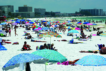
Human respiratory impacts happen when the Florida red tide organism, K. brevis, is present and winds blow onshore or alongshore. Most people experience minor respiratory irritation – coughing, sneezing, teary eyes and an itchy throat — when red tide is present and winds are blowing onshore. These symptoms go away when they leave the beach.
But people with chronic lung problems like asthma and chronic obstructive pulmonary disease (COPD) can have severe reactions when they breathe in airborne red tide toxins — even ending up in the emergency room. Health officials advise that these people avoid red tide areas altogether and take all medications as prescribed, including having access to rescue inhalers. People with chronic lung disease should leave the beach if they begin experiencing respiratory problems, even if red tide is at very low or low concentrations.
Who is this product for?
Gulf Coast residents and visitors who want to know if the beach they are planning to visit is being impacted by Florida red tide. Resource managers and researchers will also find this information helpful.
Features
The Red Tide Respiratory Forecast is provided in three-hour increments projected out over a 24-hour period and includes other details like wind speed and direction. It lists the risk level as:
- Absent/Very low: Meaning there is a low risk of irritation among most beachgoers but that people with lung disease should leave the area if they begin feeling impacts.
- Low: A low risk of irritation among most beachgoers but that people with lung disease should leave the area if they begin feeling impacts.
- Moderate: Moderate risk of irritation for most people; people with lung disease should avoid this area.
- High: High risk of irritation for most people; people with lung disease should avoid this area.
How was this tool developed?
In 2004, the National Oceanic and Atmospheric Administration’s National Ocean Service (NOAA-NOS) and partners started issuing twice-weekly condition reports and bulletins that identified the risk of respiratory irritation for three-to-four-day periods on a county-by-county level. The information is now released through the National Weather Service’s regular Beach Hazard Statement alerts.
This Red Tide Respiratory Forecast builds on NOAA’s condition reports and bulletins by providing information at a finer scale — at the beach level, not just the county level.
This experimental forecast was initially developed by NOAA’s National Ocean Service in partnership with GCOOS, the Florida Fish and Wildlife Conservation Commission-Fish and Wildlife Research Institute (FWC-FWRI) and Pinellas County Environmental Management. The forecast was developed through funding from the NASA Health and Air Quality Program and is hosted by GCOOS.


