Featured News

Gulf Glider Deployment Plans 2023

By:
Posted: June 16, 2023
Category: Featured News

June 1 kicked off the official start of the Atlantic hurricane season. NOAA is forecasting 12 to 17 total named storms: five to nine hurricanes (winds of 74 mph or greater); one to four category 3, 4, or 5 hurricanes (winds of 111 mph or greater).

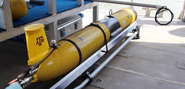
While peak season doesn’t typically occur until later in the summer — August and beyond — now is the time for everyone to prepare. That’s not just true for households and coastal communities — glider operators in the Gulf are also getting ready by preparing AUVs for launch and planning missions focused on gathering critical ocean temperature data needed by the National Weather Service and other hurricane modelers to help predict storm intensification.

Gulf operators meet regularly as a group and also participate in calls sponsored by the National Hurricane Glider Program to discuss deployment strategies, coordinate observations and provide status updates.

This year, GCOOS is supporting 18 glider missions that will be launched by Texas A&M University’s Geochemical and Environmental Research Group (GERG), the University of Southern Mississippi (USM), the University of South Florida (USF) and the Sarasota-based Mote Marine Laboratory (MML). The U.S. Navy is also taking part by providing five gliders for launch by GERG, USM and USF. The majority of the missions will take place during peak hurricane season.

“Much of the focus of our glider missions during hurricane season is on gathering ocean temperature data in the upper water column to depths of up to 200 m of the Gulf, because that is one of the main driving factors for storm intensification,” says GCOOS Oceanographer Dr. Uchenna Chizaram Nwankwo, who helps to coordinate mission planning in the Gulf. “We also track the Loop Current (LC) and the associated anticyclonic eddies that break off from the LC because they transport warmer water that fuels hurricanes, too.”

Glider missions are tracked on GCOOS’s glider piloting dashboard GANDALF — https://gandalf.gcoos.org — which provides real-time vehicle positioning information via a maps-based interface with a dashboard display, plots of flight and science sensors, Google Earth KMZ file generation and access to processed data files. GANDALF is equipped with numerous layers that can be individually displayed on the base map. Each layer’s transparency can be individually adjusted allowing for multiple layer overlays.

In addition to tracking the GCOOS-supported gliders, GANDALF will also be tracking gliders and Seagliders from the southern Gulf of Mexico launched by Centro de Investigación Científica y de Educación Superior de Ensenada’s (CICESE) Grupo de Monitoreo Oceanográfico con Gliders (GMOG).

GMOG is working in Mexico tackling national priorities to deliver near real-time hydrographic and total horizontal velocity profiles of the Mexican Caribbean region for numerical modelers, mainly to improve forecasting of the Loop Current system and hurricane intensification. They intend to carry out three 60-90-day deployments, mainly in Mexican Caribbean waters, to sample the velocity in the core of the Yucatan Current as well as the main thermohaline properties of the water column of the current.

  • Watch real-time autonomous vehicle tracking on GANDALF right now & make sure to bookmark this page to track deployments throughout the summer.
  • Learn more about the GMOG research and glider missions on their visualization platform.

Share this on social media

^